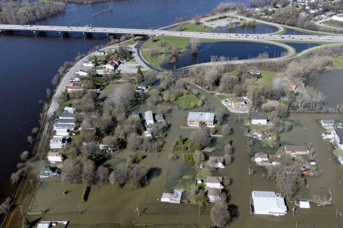
(Montreal) Even if the floods continue to be a concern in Quebec, everything indicates that the situation was stabilizing on Sunday. The Outaouais and the Laurentians remain the most affected regions, at a time when several municipalities are becoming aware of the extent of the damage.
In Outaouais, 23 municipalities are affected by flooding, and 18 in the Laurentians, according to data from the Ministry of Public Security. The Lanaudière and Montérégie regions follow closely behind, with 15 and 10 municipalities respectively suffering the impacts of flood waters.
However, the various indicators are encouraging. “Over the whole province, the situation is improving very well, considering that we have good weather, dry weather, and that it will continue for a few more days. All the rivers are down,” said Joshua Ménard-Suarez, spokesperson for civil security at the Ministry of Public Security. Dry weather is expected to remain in the province at least until Wednesday.
“Since we’re going to have had several days with low streams, there are streams that had completely flooded, and as we speak [Sunday], they’ve already returned to their normal beds.” , explains the spokesperson. He points out that if precipitation occurs again, the waterways are now able to accommodate a certain amount of rain before being flooded.
Joshua Ménard-Suarez, however, specifies that the spring flood season is not over.
The Ottawa River is one of the waterways with a major flood level. At the height of the Hull marina, the Government of Quebec reports an average flood threshold. However, major flooding is still observed in the small municipality of Fort-Coulonge, in Outaouais.
The City of Gatineau said in a statement Saturday that water levels began to stabilize from Friday. “The slow and gradual decline, meanwhile, could begin from the beginning of the week. Remember that the entire local population must remain vigilant and leave their protections in place, because the situation is still precarious, “reads the municipality’s press release, which reminds citizens not to drive in flooded areas.
As of Saturday, 137 people affected by Gatineau were being cared for by the Red Cross and staying at hotels.
The second most monitored watercourse is Lac des Deux Montagnes. A major flood threshold is still reported in Pointe-Calumet, a municipality in the Laurentians region. Also on the shores of Lac des Deux Montagnes, moderate flooding has been reported in the towns of Terrasse-Vaudreuil and Sainte-Anne-de-Bellevue.
In Bois-des-Filion, the Rivière des Mille-Îles has an average flood threshold, as does that of the Rivière Rigaud, on the edge of the municipality of the same name.
In Montreal, the level of the St. Lawrence River is under surveillance. Minor flooding was reported along the Rivière des Prairies in the west of the island, near Île Bizard. Some roads are still closed to traffic, including the Île Mercier bridge. A portion of Chemin du Bord-du-Lac on Île Bizard, Boulevard Lalande, Chemin de l’Anse-à-l’Orme and Boulevard Gouin are also inaccessible.
As far as Mauricie is concerned, minor flooding has been reported along Lake Saint-Pierre and Lake Maskinongé.
The risk of landslides is on the rise when the ground is waterlogged, as it is now, warns Joshua Ménard-Suarez.
“Landslides are a little more sneaky, it can happen just about anywhere, and it’s harder to see clues, traces of what’s coming. This means that we often invite citizens to look at their land, to note if there is anything unusual, a crack that was not there before, a subsidence” and to notify their municipality. , recommends the spokesperson.


